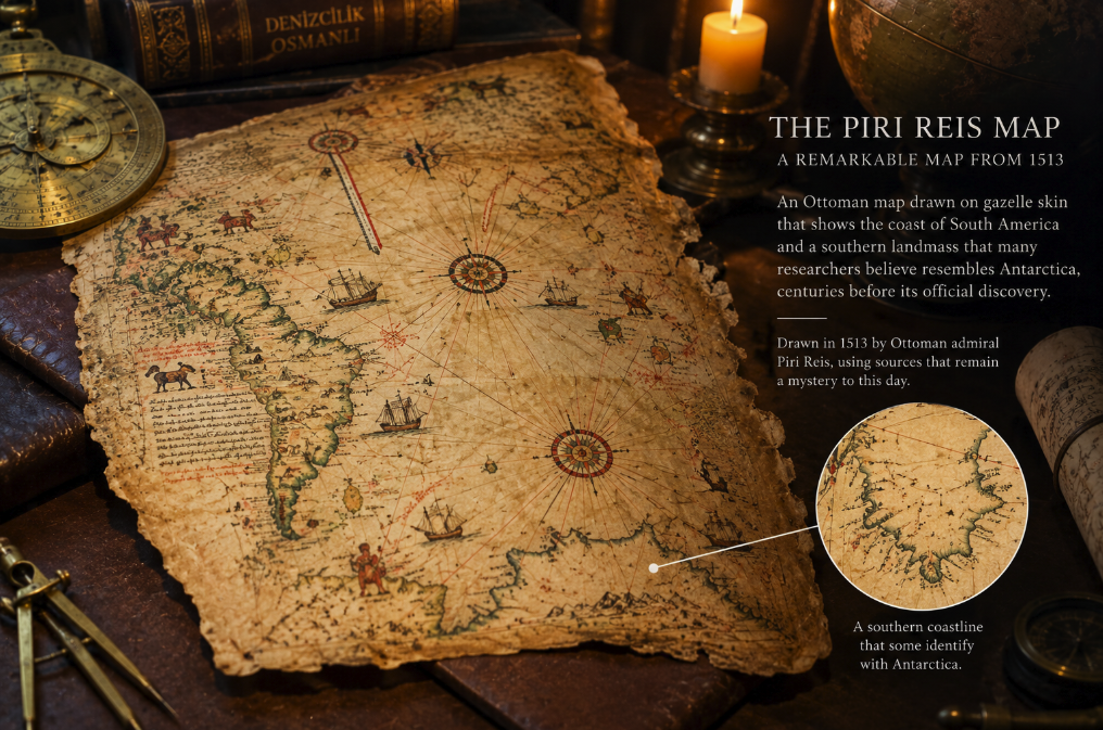
In 1929, while scholars were cataloguing manuscripts in Istanbul's Topkapı Palace, they encountered a fragment of an extraordinary world map. Painted in vivid colors on parchment traditionally described as gazelle skin, it showed the Atlantic, western Africa, parts of Europe and a surprisingly recognizable coastline of South America.
An inscription identified its maker: Piri Reis, an Ottoman naval commander and cartographer. Another supplied the date, 919 in the Islamic calendar — 1513 CE.
The map was remarkable enough on its own. It had been drawn barely two decades after Columbus's first Atlantic voyage, when European and Mediterranean cartographers were still struggling to understand the shape of newly encountered American coastlines. Piri Reis had somehow assembled geographical information from different civilizations into one sophisticated nautical chart.
Then a far more sensational story took hold.
The map's South American coast bends sharply eastward near its southern end and continues across the bottom of the surviving fragment. Some writers claimed this coastline was not South America at all but Antarctica — supposedly shown centuries before the continent's confirmed nineteenth-century exploration. More dramatic versions argued that it represented Antarctica without its ice sheet, implying access to maps made by an unknown ancient civilization.
It is one of the most persistent mysteries in alternative history.
It is also a case where the genuine mystery is more interesting than the sensational explanation. The Piri Reis map really is an exceptional document from 1513. It really does incorporate geographical knowledge from lost earlier maps. But there is no compelling evidence that it contains a scientifically accurate map of Antarctica.
An Ottoman admiral at the edge of a changing world
Piri Reis was born around 1470 in Gallipoli, an important Ottoman naval center. He became a sailor, naval commander and cartographer during a period when Mediterranean maritime traditions were colliding with the geographical revolution created by Portuguese and Spanish oceanic voyages.
By 1513, Europeans had been sailing regularly to the Americas for two decades. Portuguese navigators had explored much of the Atlantic coast of South America. Cartographers were rapidly incorporating reports from expeditions into new charts, often while still misunderstanding how the newly encountered lands fitted into the global geography inherited from classical writers such as Ptolemy.
Piri Reis stood at this crossroads.
His surviving map is a portolan-style chart, drawing on the practical nautical mapping tradition developed by Mediterranean mariners. It contains compass roses, rhumb lines, ships, animals, rulers and extensive Ottoman Turkish annotations.
UNESCO added the Piri Reis World Map of 1513 to its Memory of the World Register in 2017, describing it as an exceptional synthesis of Eastern and Western geographical knowledge and one of the earliest cartographic records of the discoveries in the New World.
Only part of the original map survives. That fact is crucial: we are not looking at Piri Reis's complete world.
Piri Reis told us where his information came from
One reason the map fascinates historians is that its creator left notes explaining his sources.
Piri Reis did not claim to have personally explored the American coast. Instead, he described his work as a compilation.
A 1933 Library of Congress report discussing the newly rediscovered map summarized his source list: Ptolemaic maps, an Arabic map of India, several recent Portuguese charts and a map associated with Christopher Columbus.
This is an extraordinary statement about how geographical knowledge traveled in the early sixteenth century.
Maps were valuable strategic documents. Sailors captured enemy ships, governments guarded navigational information, and charts were copied, modified and combined. A cartographer in the Ottoman world could therefore acquire geographical information generated by Portuguese or Spanish expeditions without ever crossing the Atlantic.
The map's importance is partly that some of Piri Reis's sources are now lost. His chart may preserve traces of cartographic information that otherwise disappeared.
That does not require a vanished prehistoric civilization. The Age of Discovery itself generated plenty of lost maps.
The Columbus connection is real
Among Piri Reis's annotations is a reference to a chart associated with Columbus. No authenticated original world or navigation map drawn by Christopher Columbus survives today.
That makes the Ottoman map particularly valuable.
UNESCO's nomination dossier describes the Piri Reis map as the earliest surviving cartographic record incorporating information from Columbus's oceanic voyages. Its representation of Caribbean geography is strange by modern standards, but some of those peculiarities may reflect early Columbian ideas about the islands and Asian geography.
The result is almost like a cartographic fossil. Piri Reis copied and transformed information from earlier sources, preserving aspects of maps that disappeared.
This alone is enough to make the object historically exceptional.
So where does Antarctica enter the story?
At the southern end of the map, the coastline of South America curves sharply eastward instead of continuing south in anything resembling the real shape of Patagonia and Tierra del Fuego.
To a modern viewer, rotating or reinterpreting this extension can make it look vaguely suggestive of a coastline stretching toward Antarctica.
That resemblance inspired the famous claim.
But similarity is not identification.
The geography contains serious problems if the southern land is supposed to be Antarctica. Relative positions, scale, orientation and coastal shapes do not provide the kind of consistent match expected from an accurate survey. The map also belongs to a period when cartographers routinely represented speculative southern lands.
For more than two thousand years, geographers had imagined that a great southern continent might exist. The idea was not based on Antarctic exploration. It grew from ancient theories that land in the Northern Hemisphere should be balanced by land in the south.
This hypothetical territory became known as Terra Australis.
As historian Carl Murray discusses in the Cambridge journal Polar Record, imagined southern continents appeared on maps long before Antarctica was actually known. Cartographers were perfectly capable of drawing a southern landmass without having geographical information about the Antarctic continent.
The coastline may simply be South America bent out of shape
There is an even simpler explanation for the mysterious southern extension.
Early sixteenth-century maps frequently contained major distortions. Longitude at sea could not yet be measured reliably. Cartographers combined sources created at different scales and with incompatible assumptions. Coastlines could be rotated or compressed to fit available parchment.
Piri Reis himself was compiling multiple charts rather than working from a modern coordinate grid.
The southern extension can therefore be understood as a distorted continuation of South America, perhaps combined with ideas about a hypothetical southern continent. Cartographic historians do not need Antarctica to explain why the coast turns east.
This is also consistent with the intellectual world in which the map was made. In 1513, the precise southern extent of South America was still unknown to European and Mediterranean cartographers. Ferdinand Magellan would not pass through the strait bearing his name until 1520.
Piri Reis was drawing the edge of geographical knowledge while the geography itself was still being discovered.
What about the famous “ice-free Antarctica” claim?
This is the most dramatic version of the legend.
It proposes that the Piri Reis map depicts the coastline of Antarctica beneath its ice, meaning its source must preserve geographical knowledge from a remote era when the continent was ice-free. The argument became especially popular in twentieth-century speculative literature.
The geological timeline creates an immediate problem. Antarctica has carried extensive ice sheets for millions of years. Human civilization did not exist during a period when the continent possessed the modern-looking ice-free coastline imagined by the theory.
Modern subglacial mapping also does not rescue the claim. The shape of land beneath Antarctic ice is not simply identical to the visible edge of the modern ice sheet, and matching a distorted sixteenth-century drawing to selected modern contours is highly subjective.
Most importantly, there is no documentary chain connecting Piri Reis to an ancient Antarctic survey. His own source note points instead toward known cartographic traditions: classical geography, Arabic material, Portuguese exploration and Columbus-era charts.
An extraordinary explanation is unnecessary when the map itself tells us that it was assembled from the geographical knowledge circulating around the Mediterranean in Piri Reis's lifetime.
Why UNESCO mentions Terra Australis
There is a nuance worth preserving. UNESCO describes the map as being among early works showing Terra Australis.
That wording can sound like official confirmation that Piri Reis mapped Antarctica. It is not.
Terra Australis was a conceptual southern continent, not necessarily the real Antarctic landmass as we understand it today. Renaissance maps often gave this imagined territory elaborate coastlines, mountains, animals and names despite the absence of direct observation.
The distinction between “a southern continent appears on the map” and “the map accurately depicts Antarctica” is fundamental.
Maps do not contain only measurements. They also contain theories, guesses, inherited traditions and attempts to fill unknown spaces.
The map really was drawn on an unusual material
The surviving chart is commonly described as having been drawn on gazelle skin. The Library of Congress's early investigation explicitly called it a manuscript map on gazelle skin, and that description has been repeated widely.
Like many high-value manuscripts of its era, the map was produced on prepared animal skin rather than modern paper. Its irregular surviving shape is partly the result of being only a fragment of a larger original world map.
Its illustrations are as important as its coastlines. Ships sail across the Atlantic. Exotic animals occupy newly mapped territories. Human figures, rulers and mythical creatures appear alongside geographical information.
To modern eyes, this can look decorative. To a sixteenth-century cartographer, geography, political knowledge, travel narrative and inherited legend could coexist naturally on the same surface.
The map is therefore not a satellite image rendered imperfectly. It is a visual encyclopedia of what its maker thought was known about the Atlantic world.
The real mystery is the network behind the map
Removing Antarctica from the story does not make Piri Reis less remarkable. It makes his actual achievement easier to see.
In 1513, an Ottoman admiral had access to information derived from some of the newest Portuguese and Spanish voyages. He combined it with older Mediterranean, Arabic and classical sources. He apparently incorporated material associated with Columbus from a chart that no longer survives. He then synthesized those incompatible traditions into a single world map only twenty-one years after Columbus first crossed the Atlantic.
That is evidence of an information network far more interconnected than simplistic histories of the Age of Discovery sometimes suggest.
Knowledge did not belong neatly to one empire. Maps crossed borders through trade, espionage, capture, copying and conversation among sailors. Piri Reis worked in an Ottoman Mediterranean connected to Italian, Iberian, North African and Middle Eastern maritime worlds.
His later Kitab-ı Bahriye, or Book of Navigation, confirms the depth of that tradition. The Library of Congress describes the work as an extensive navigational guide containing hundreds of maps and portolan charts of Mediterranean and Black Sea coasts.
Piri Reis was not a mysterious custodian of prehistoric technology. He was something historically more plausible and arguably more impressive: an expert cartographer working at the intersection of several sophisticated geographical traditions.
A mystery created partly by hindsight
Modern viewers know Antarctica exists. Piri Reis did not possess that certainty.
That difference changes how we see the map.
When we encounter an unexplained southern coastline, our eyes naturally try to match it to a continent familiar from modern globes. A sixteenth-century viewer approached the same empty southern ocean with inherited ideas about Terra Australis, incomplete reports of South America and no reliable method for determining longitude at sea.
The Piri Reis map is extraordinary precisely because it preserves that moment of uncertainty.
Europeans had reached the Americas but did not yet understand their full shape. The Pacific had not yet been crossed by Magellan's expedition. Antarctica remained unknown to direct observation. Old Ptolemaic geography coexisted with information arriving from Atlantic voyages. Mythical creatures could share parchment with remarkably accurate coastal details.
The map sits on the boundary between medieval cosmography and modern global cartography.
Its famous Antarctic mystery says as much about twentieth-century imagination as it does about 1513.
The real artifact needs no lost civilization to be astonishing. Piri Reis created a map from fragments of a world whose geography was changing faster than cartographers could redraw it. Five centuries later, some of his sources have disappeared, leaving his parchment as the only surviving witness to information that once passed through the hands of sailors, explorers and mapmakers.
That is the genuine mystery of the Piri Reis map: not how an Ottoman admiral knew the coastline of Antarctica, but how much geographical knowledge once existed on maps that history failed to preserve.